|
Dye job to aid fishery understanding |
|
September 18, 2017 |
 |
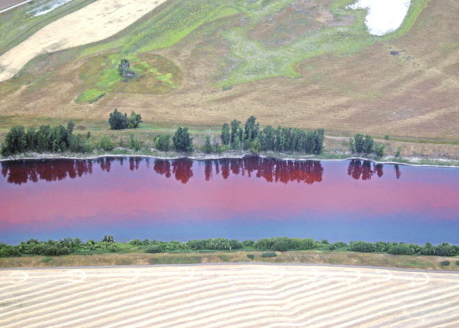
| Aerial view
of a USGS dye tracer study done on the
Kootenai River in 2008. |
|
From September 24 through 29, scientists from
the U.S. Geological Survey will conduct dye
tracer and aerial mapping studies on the
Kootenai River. Data from the studies will
support Idaho Department of Fish and Game and
Kootenai Tribe of Idaho fisheries and river
restoration projects.
USGS scientists will inject a harmless, bright
red fluorescent dye into the Kootenai River
downstream of its confluence with Deep Creek
near Bonners Ferry. The goal of the dye study is
to understand where and how fast larval sturgeon
and burbot move downstream to Kootenay Lake in
British Columbia.
“Data from the dye tracer study will be
instrumental in helping us better understand how
and where young sturgeon and burbot move in the
river after they hatch from their eggs,” said
T.J. Ross, Senior Fisheries Research Biologist
with IDFG. “This knowledge will get us one step
closer to providing the conditions necessary for
these fish to naturally reproduce in the
Kootenai River as they once did.”
The red dye is approved for use as a water
tracer by the U.S. Environmental Protection
Agency and is harmless to people, fish and
plants at the concentration being used for this
study.
For a few hours after the start of the study,
several miles of the river will appear reddish
in color because of the dye. The red color will
dissipate rapidly and should disappear after it
travels downstream near Copeland.
Citizens may also notice an airplane regularly
passing over the river. The airplane will be
equipped with Light Detection and Ranging
technology to map the land surface around the
river (topography) and under the water
(bathymetry) as part of the USGS 3D Elevation
Program.
This study will be one of the first to combine
topographic and bathymetric lidar data
collection.
“The lidar flight will provide detailed
elevation data in areas that would otherwise be
challenging to survey,” said Susan Ireland, Fish
and Wildlife Department Director for the
Kootenai Tribe. “The data will support our
existing habitat restoration projects and could
be useful for future restoration project design,
implementation and biological assessment work.”
USGS scientists will use the data collected from
both studies to improve computer models that let
fisheries managers simulate various river
conditions to see how those conditions might
affect fish spawning. The scientists also hope
to be able to use lidar imagery to estimate the
river’s water-quality conditions such as
turbidity.
If successful, this innovation would save time
and money compared with manual water-quality
sampling. |
|
Questions or comments about this
article?
Click here to e-mail! |
|
|
|
|

